Parade of winter storms to blast across US with snow expected for 200 million in 40 states
BOSTON – If you were hoping the US had turned a corner and more springlike weather was on the way, you’re going to have to hold on a bit longer as the FOX Forecast Center tracks what is shaping up to be an incredibly active week for winter weather across the nation.
This renewed threat comes just as millions of people across the Northeast and New England clean up in the wake of a winter storm over the weekend that dumped several inches of snow across the region.
Triple threat of winter storms looms this week
The FOX Forecast Center said at least three separate winter storms are expected to sweep across a large portion of the US during the week ahead, bringing the threat of widespread snow and ice to tens, if not hundreds, of millions of Americans from coast to coast.
Flooding, too, will be a concern, as torrential rain to the south falls across the Southeast as the parade of storms sweeps across the US.
First winter storm develops in Plains Monday, sweeps into mid-Atlantic Tuesday
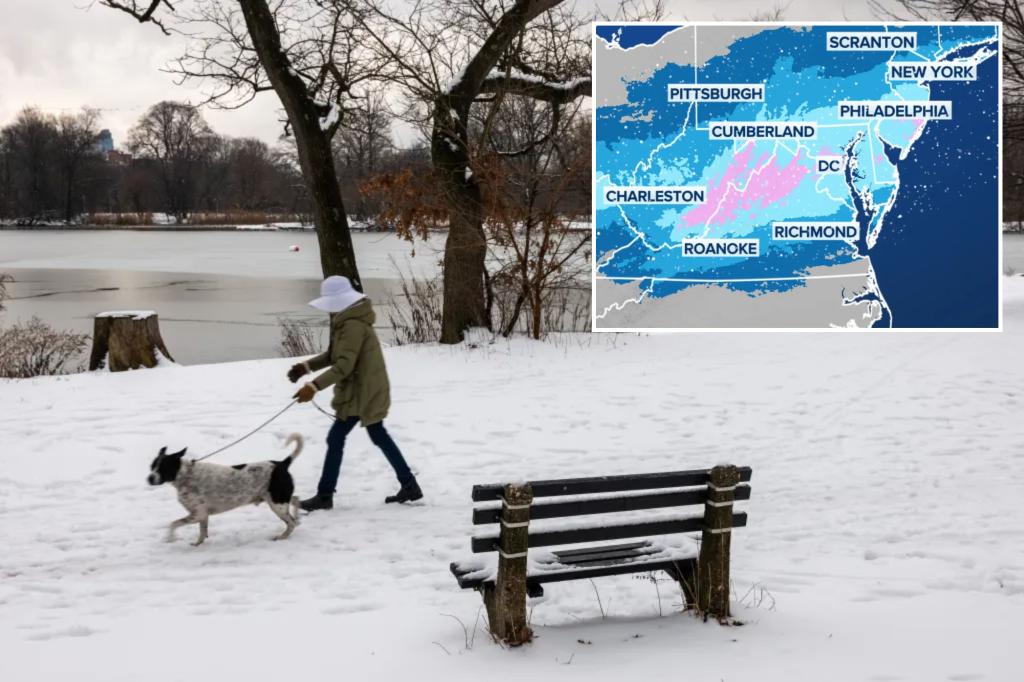
The first winter storm of the series is expected to develop over the Plains later Monday before blasting across the Ohio Valley and into the mid-Atlantic on Tuesday.
This storm, the FOX Forecast Center said, will track farther to the south than the storm that impacted millions in the Northeast and New England over the weekend, with the snow bull’s-eye setting up across the mid-Atlantic states.
Unlike the previous storm, this one will lack a well-defined area of low pressure, which will then limit the amount of cold air available to mix in with the moisture streaming in from the South.
As a result, while snow will fall across nearly two dozen states, forecast snow totals are expected to be light to moderate due to the lack of cold air.
Nonetheless, winter weather alerts have been posted for millions of people from the Plains to the East Coast.
A Winter Storm Watch extends from portions of eastern Colorado through most of Kansas, southern Nebraska, central and northern Missouri, southeastern Iowa and western Illinois.
Cities such as Goodland, Hays, Wichita and Topeka in Kansas are all included in the Winter Storm Watch.
Kansas City, St. Joseph and Columbia are among the cities in Missouri that are also included.
The National Weather Service said the storm will exit the Rockies on Tuesday and will impact the central Plains from Tuesday afternoon into Wednesday.
Heavy snow is possible by early Wednesday, with some snowfall rates of around an inch per hour that could allow about 5 inches of snow accumulation for much of central Kansas along the Interstate 70 corridor.
Kansas Gov. Laura Kelly issued a verbal state of disaster emergency proclamation over the weekend due to the impending winter storms that will impact the state this week.
“Kansans have faced challenges due to winter storms this year,” Kelly said in a statement. “The key to meeting those challenges is to be prepared. As I did during past storms, I urge all Kansans to take measures to make sure their families are ready by making a home emergency kit and emergency plan.”
In addition, Kelly urged residents to avoid travel if possible. If travel is needed, it is advised to tell someone your travel plans, ensure the vehicle has a full tank of gas, and keep an emergency kit inside the vehicle.
After impacting the Plains, the storm is expected to move into the Ohio Valley, and then slam the mid-Atlantic and portions of the Northeast into Wednesday morning before the system pushes offshore.
Richmond, Virginia, Washington and Baltimore are under Winter Storm Watches through Wednesday. Heavy snow is possible, with totals between 4 and 6 inches. Winter Storm Warnings are in effect for portions of northwestern North Carolina, central and western Virginia and eastern West Virginia.
Second storm develops as first pushes off East Coast
As that first storm begins to wind down over the mid-Atlantic and Northeast on Wednesday, the second storm will already be developing over the Plains.
The FOX Forecast Center said the storm will spread snow into the Midwest by Wednesday night before setting its sights on the Northeast on Thursday.
The FOX Forecast Center said this storm could potentially produce the highest snow totals of the three, as heavy snow is looking more likely from the Plains to New England.
As of Monday, the FOX Forecast Center said the busy Interstate 95 corridor is looking more wet than white, but that will come into better focus as the week goes on.
Third storm to impact some weekend plans
The last storm, for now, is expected to take shape late this week and continue into the weekend, bringing yet another round of winter weather to cities from the Plains to New England.
The FOX Forecast Center said this relentless winter weather pattern could continue into next week, but it’s still too soon to know that for certain.