Heavy snow moves into Chicago, Detroit as winter storm unleashes its wrath across Midwest
A powerful and deadly winter storm that has been slamming the Plains and Midwest Wednesday morning moved into Chicago, Detroit and the Great Lakes during the afternoon, making for treacherous travel through the evening.
The FOX Forecast Center said that out of all the storm systems that were tracked this week, this one looks to be the snowiest in terms of totals and coverage.
It’s also bringing a dangerous severe weather threat to the South.
Snowfall rates of about an inch per hour are expected to produce multiple inches of snow accumulation along the storm’s path, stretching from central Kansas northeastward through much of lower Michigan, including Chicago, Milwaukee and Detroit.
Snowfall totals reached 2-3 inches around the Kansas City area as the storm pushed through Wednesday morning.
Snow had moved into the Great Lakes area Wednesday evening, dumping snowfall at rates of 0.5-1.0 inches per hour across the evening commutes in Chicago, Milwaukee, and Detroit.
According to the FOX Forecast Center, this winter storm could be the biggest snowstorm of the season so far for those three cities.
Still, it’s unlikely to end Chicago’s seasonal snow deficit.
Chicago’s biggest single storm of the year was 2.2 inches on Jan. 10, while Detroit received 4.3 inches between Jan. 10 and 12.
Snow storm turns deadly in Missouri
The winter storm began Wednesday dumping snow in Kansas and Missouri quickly making for treacherous driving conditions.
According to Missouri State Highway Patrol Troop F, one person died in a rollover crash near Holts Summit on eastbound US-54.
Elsewhere in the state, there were multiple crashes on state roads and highways throughout Wednesday, including a crash that blocked Interstate 35 in Clay County.
Kansas State Police said troopers responded to numerous reports of crashes and spinouts, including one that injured someone near Junction City.
State office buildings closed on Wednesday in Shawnee County, Kansas, due to the winter weather.
Thundersnow was also reported in Oklahoma City and Norman, Oklahoma, early Wednesday morning.
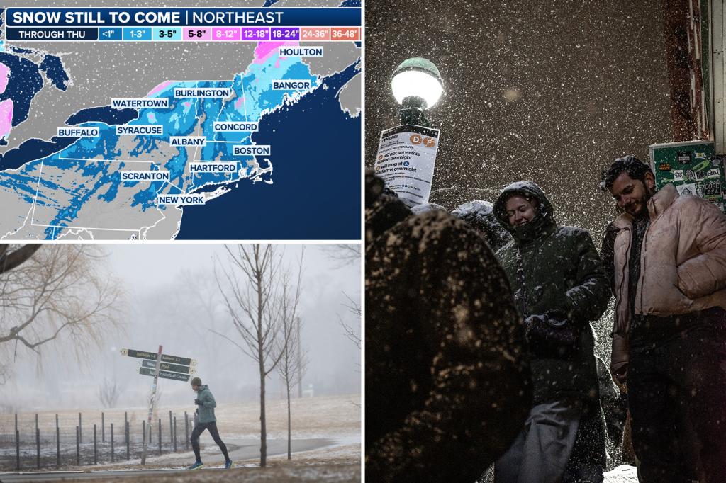
Storm moves into Northeast, New England on Thursday
After moving through the Great Lakes region Wednesday night, the winter weather spins off into the Northeast and New England overnight into Thursday.
But as the storm moves into the region, it will bring with it some warmer air from the south.
That will lead to a mix of precipitation types, including snow, sleet, freezing rain and just plain rain.

Snow will likely fall on the storm’s onset before it quickly changes over for nearly everyone in the Northeast, except for those closer to the U.S.-Canada border.
A Winter Storm Warning has been issued for northern Maine due to the threat of up to a foot of snow.
To the south of the heavy snow, a winter mix and ice will occur from the central Appalachians into central New England.
Ice accretions of up to a tenth of an inch will lead to treacherous travel conditions across the region for the Thursday morning commute.
The major cities along the Interstate 95 corridor, like New York City and Philadelphia, may see some snowflakes before changing over to rain.
The parade of storms will continue until at least the weekend as the FOX Forecast Center tracks yet another storm system that will also include a severe weather component.